Sailing the West Coast of Ireland
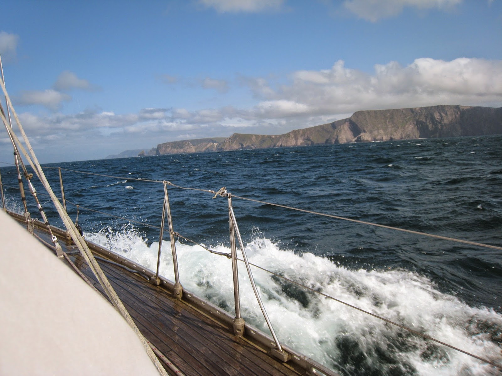 |
| Sailing around the cliffs of Achill |
Remote and Wild
by Daria Blackwell
s/v Aleria
Co-author of Happy Hooking The Art of Anchoring.
We emerged from the shelter of the inner islands only to find a furious chop in the bay. It was supposed to be fairly benign conditions today, but the wind was howling in from the West whipping up the seas against the outgoing tide. There was a huge swell coming in from the Atlantic, which we had expected behind the retreating gale from the day before, but we had not expected this maelstrom given the Met Eireann forecast early this morning. But that's the west coast of Ireland. Unpredictable. Majestic. And many days formidable.
There are few places on this earth that are more beautiful, more wild, or more remote than the West Coast of Ireland. "What?" you say, "But its in Europe. Europe has been populated for centuries, millennia even. Europe is where civilization took off." Ah, but Ireland is at the wild Atlantic edge of Europe. The lands are not productive. The cliffs are forbidding. The harbours are inhospitable. In essence, the remoteness and inaccessibility of Ireland's rugged West Coast, as well as its wild weather, has been its salvation. It's why the Wild Atlantic Way, and now the Blue Way, is of great interest suddenly. Untamed. Adventurous. And right here. It's astounding really.
Want to go where the land is unspoiled? Want to see the land as the early Christian pioneer navigators and their Viking rivals saw it? Come to Ireland, but you'd better come prepared. There are no mega marinas, no services, few water or fuel docks, certainly no pump-out stations. There are no harbourmasters per se, few immigration or customs offices, and no harbourside amenities for the most part. Outside of Galway, where you can be tucked into the harbour in the middle of the medieval section of town - the epicentre of life in Galway, there is little access to modern conveniences out here. Even in Galway, you have to prearrange fuel delivery by truck, although water and electricity are now available at the docks.
Once past Galway, you are basically on your own. There are no marinas between Galway and Derry (Londonderry) in Northern Ireland. To get fuel, you will need to use jerry cans to shuttle it from fuel stations sometimes a fair distance from the dinghy landing point or from town. The same goes for groceries, although some of the islands have basic provisions. There are few laundry facilities and skips for garbage. To haul out, you need to hire a crane or make it into Killybegs in Donegal, a fishing harbour, or Kilrush, a locked marina, on the Shannon River. Truly, it is about as remote as you can get.
 |
| Cetaceans are common sightings |
What there is
Two things are prevalent in the West of Ireland: natural, unspoilt beauty and historical treasures. From the tallest cliffs in Europe (Achill Island and Slieve League) to the most dramatic stacks at Downpatrick Head, from the cliff diving on Inishmore to the natural arches on Gola, you won't find many places more beautiful. |
| Downpatrick Head in County Mayo |
Journey through time: Mesolithic earliest people, Neolithic Bronze Age, Iron Age Early Christian, Medieval Pirates, Gaelic Lordships Plantation, Napoleonic Wars, WW 2, Present-day adventurers
And discover earth's history as well as man's: http://www.dcenr.gov.ie/Spatial+Data/Geological+Survey+of+Ireland/
Weather & Tides Forecasts
For tides information see http://www.pocketsizetides.com. The tidal range is about 15 feet (4.5 meters) so it is critical to pay attention when anchoring.
Despite being a relatively small island nation, the weather is tremendously variable from one part of the country to another. Small wonder that weather is the most common topic of conversation. On the West Coast, it feels like being on a ship at sea at times. We get hurricane-force winds throughout the winter. In the summer, the best months tend to be May and June, although July can be lovely as well. August and September tend to get wetter as the tropical storms begin their annual procession across the Atlantic. Most people don't realize that many of them end up here. October is often a beautiful month, but the chances of rapid deterioration increase dramatically at the height of the Atlantic hurricane season. Usually, you want to be on your way out of here by the 1st of October if you are visiting by boat.
 |
| The lighthouse on Inishgort in Clew Bay |
Met Eireann Sea Area Forecast: http://www.met.ie/forecasts/sea-area.asp
The marine forecast, usually delivered via FM radio on RTE1 just before 1300 daily, is repeated by the Coast Guard on the local VHF channels around the coast. It will be announced on VHF channel 16, but you will have to switch to the station working channel nearest your location for the actual broadcast. A new channel 05 was added for Clew Bay (between Clifden and Belmullet) in 2019. Channel 70 is reserved for DSC and 72 is reserved for ship-to-ship non-commercial traffic.
 |
| VHF channels in use by the Irish Coast Guard |
Sea Area Forecasts are broadcast every 3 hours beginning at 0103 local time, i.e. VHF broadcast times are: 0103, 0403, 0703, 1003, 1303, 1606, 1903, 2203 local time.
Gale Warning broadcasts are also preceded by an announcement on Marine VHF Ch 16. They are broadcast on receipt and are repeated at the next one of the following times: 0033, 0633, 1233 and 1833 local time.
To understand the marine forecast's relevance to your cruising area, you need to know where you are relative to the geographic regions being reported. Ireland's weather is reported by headland to headland. They might report from Malin Head to Slyne Head which covers the northwest corner. In Clew Bay, you need to know that you are between Erris Head and Slyne Head, but you also need to know all the other points from which they might begin the stretch of coast for the report.
 |
| Headlands and points used to denote regional weather forecasts and conditions |
Navigation
 |
| A rocky coastline that is navigationally interesting |
 |
| Chart datum dating back to the 1800s and few navaids |
 |
| Spectacular scenery in Clew Bay with Clare Island |
AIS navigation is being installed around the coast and all lighthouses are getting their own beacons. The first virtual aid to navigation was recently installed in Northern Ireland so perhaps there will be good news for the rest of the island. Both the Coast Guard and the RNLI operate lifeboats in Irish waters.
Galway Harbour
Inishmore
Roundstone
Clifden
Inishbofin
Killary Harbour
Inishturk
Clare Island
Westport Bay/Newport Bay/Clew Bay
Elly Bay/Saleen Bay/Blacksod Bay
Inishkeas
Portnafrankagh (French Port)
Broadhaven
Killala
Sligo Bay
Donegal Bay (town accessible only by dinghy)
Killybegs
Teelin
Aran Island/Burtonport
Cruit Bay
Gola Island
Tory Island
Sheepshead Bay
See also notes on navigational approaches to Clew Bay.
Visitor moorings and their status are listed on the ISA website and can be downloaded as a pdf. http://www.sailing.ie/Portals/0/DailyNewsFiles/county%20council%20visitors%20moorings.pdf
Route along the NW coast:
I have written about most of the stopovers on the northwest coast of Ireland in this blog. Please use the keyword listing in the right hand margin of the page to identify blog entries that pertain to each location (listed here from South to North). A few are not yet covered; if you have information that you'd like to share, please feel free to drop a comment.
Inishmore
Roundstone
Clifden
Inishbofin
Killary Harbour
Inishturk
Clare Island
Westport Bay/Newport Bay/Clew Bay
Elly Bay/Saleen Bay/Blacksod Bay
Inishkeas
Portnafrankagh (French Port)
Broadhaven
Killala
Sligo Bay
Donegal Bay (town accessible only by dinghy)
Killybegs
Teelin
Aran Island/Burtonport
Cruit Bay
Gola Island
Tory Island
Sheepshead Bay
Visitor moorings and their status are listed on the ISA website and can be downloaded as a pdf. http://www.sailing.ie/Portals/0/DailyNewsFiles/county%20council%20visitors%20moorings.pdf
This page is also saved as a static Page for reference on this blog.