Sailing the West Coast of Ireland
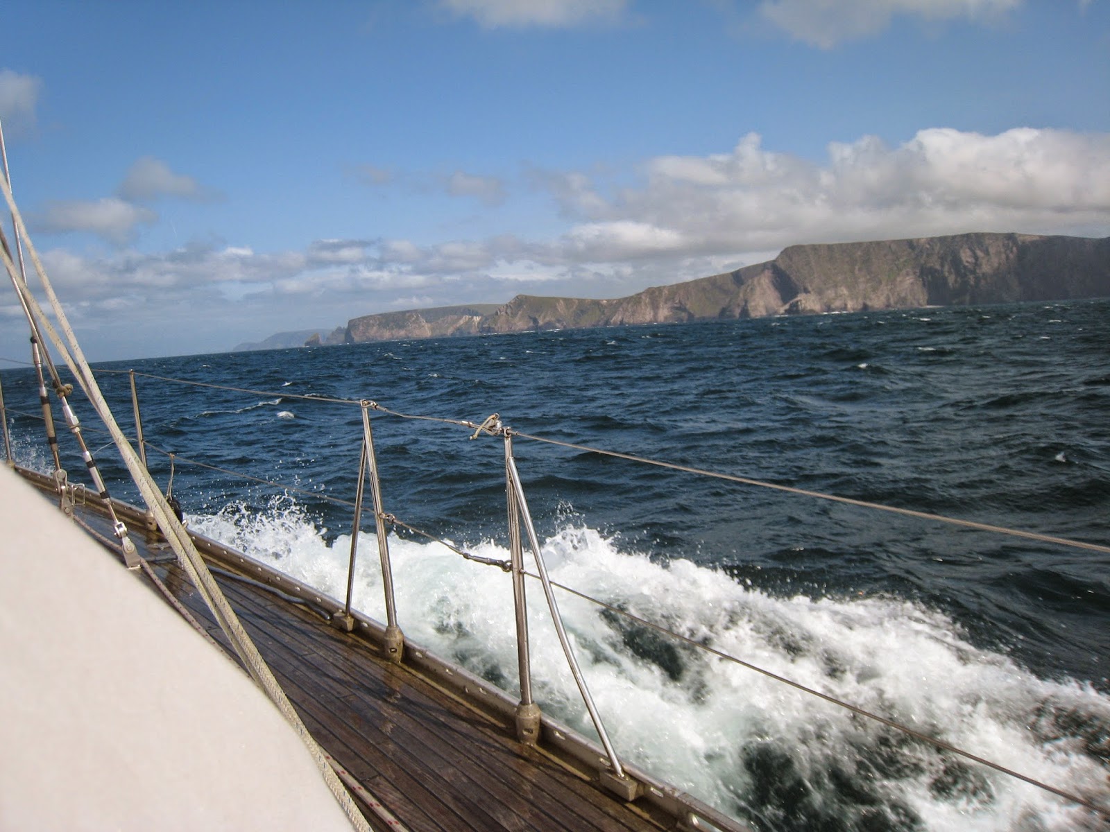 |
| Sailing around the cliffs of Achill Click on a photo to view the gallery full-sized. |
Remote and Wild
by Daria Blackwells/v Aleria
Co-author of Happy Hooking The Art of Anchoring.
and Cruising the Wild Atlantic Way
Editor for the West of Ireland for the Cruising Association Almanac
Updated 07-11-2021
We emerged from the shelter of the inner islands only to find a furious chop in the bay. It was supposed to be fairly benign conditions today, but the wind was howling in from the West whipping up the seas against the outgoing tide. There was a huge swell coming in from the Atlantic, which we had expected behind the retreating gale from the day before, but we had not expected this maelstrom given the Met Eireann forecast early this morning. But that's the west coast of Ireland. Unpredictable. Majestic. And, many days, formidable.
There are few places on this earth that are more beautiful, more wild, or more remote than the West Coast of Ireland. "What?" you say, "But it's in Europe. Europe has been populated for centuries, millennia even. Europe is where civilization took off." Ah, but Ireland is at the wild Atlantic edge of Europe. The lands are not productive. The cliffs are forbidding. Many harbours are inhospitable. In essence, the remoteness and inaccessibility of Ireland's rugged West Coast, as well as its wild weather, has been its salvation. It's why the Wild Atlantic Way is of great interest. Untamed. Adventurous. And right here. It's astounding really.
 |
| Cetaceans are common sightings |
Want to go where the land is unspoiled? Want to see the land as the early Christian pioneer navigators and their Viking rivals saw it? Come to the west of Ireland, but you'd better come prepared. There are no mega marinas, few services, few water or fuel docks. There are few harbourmasters, immigration or customs offices, and harbourside amenities for the most part. Outside of Galway, where you can be tucked into the harbour in the middle of the medieval section of town - the epicentre of life in Galway, there is little access to modern conveniences out here. Even in Galway, you have to prearrange fuel delivery by truck, although water and electricity are now available at the docks.
Once north of Galway, you are basically on your own. There are no major marinas between Galway and Derry (Londonderry) in Northern Ireland and only one small craft harbour with pontoons in Killybegs. To get fuel, you will need to use jerry cans to shuttle it from fuel stations sometimes a fair distance from the dinghy landing point or from town. The same goes for groceries, although some of the islands have basic provisions. There are few laundry facilities and skips for garbage. To haul out, you need to hire a crane or make it into Killybegs, a fishing harbour where Mooney boats have a 75-ton travel hoist and chandlery. There is also a travel hoist and wonderful marina now in Kilrush on the Shannon River.
Once north of Galway, you are basically on your own. There are no major marinas between Galway and Derry (Londonderry) in Northern Ireland and only one small craft harbour with pontoons in Killybegs. To get fuel, you will need to use jerry cans to shuttle it from fuel stations sometimes a fair distance from the dinghy landing point or from town. The same goes for groceries, although some of the islands have basic provisions. There are few laundry facilities and skips for garbage. To haul out, you need to hire a crane or make it into Killybegs, a fishing harbour where Mooney boats have a 75-ton travel hoist and chandlery. There is also a travel hoist and wonderful marina now in Kilrush on the Shannon River.
As of 2020, the fishing harbours will no longer be permitted to sell green diesel to pleasure craft, so white diesel may be relatively inaccessible to yachts transiting the west coast. For updates on the availability of fuel, visit this page.
From the rare bird colonies nesting along the islands to the sea creatures feeding in our waters, you won't find a place more invigorating. And from the remains of prehistoric tombs and ruins of monastic settlements to the deserted famine villages, you will not find a place more spiritually inspiring. It is hard to describe the experience of being the only one anchored and privileged to explore the history of man and beast. It is difficult to explain the solitude, isolation, and restorative properties of the perfect sunset. In most places, you will not see another boat. But you will feel your spirit lift to a new awareness.
Journey through time: Mesolithic earliest people, Neolithic Bronze Age, Iron Age, Early Christian, Gaelic pagans, Medieval Pirates, Lordship Plantation, Napoleonic Wars, WWII, Present-day adventurers... And connections to a time when the earth was one landmass and one ocean, you can discover earth's history as well as man's.
 |
| Downpatrick Head in County Mayo |
What there is
Two things are prevalent in the West of Ireland: natural, unspoilt beauty and historical treasures. From the tallest cliffs in Europe (Achill Island and Slieve League) to the most dramatic stacks at Downpatrick Head, from the cliffs of Inishmore to the natural arches on Gola, you won't find many places more beautiful.From the rare bird colonies nesting along the islands to the sea creatures feeding in our waters, you won't find a place more invigorating. And from the remains of prehistoric tombs and ruins of monastic settlements to the deserted famine villages, you will not find a place more spiritually inspiring. It is hard to describe the experience of being the only one anchored and privileged to explore the history of man and beast. It is difficult to explain the solitude, isolation, and restorative properties of the perfect sunset. In most places, you will not see another boat. But you will feel your spirit lift to a new awareness.
Journey through time: Mesolithic earliest people, Neolithic Bronze Age, Iron Age, Early Christian, Gaelic pagans, Medieval Pirates, Lordship Plantation, Napoleonic Wars, WWII, Present-day adventurers... And connections to a time when the earth was one landmass and one ocean, you can discover earth's history as well as man's.
 |
| The lighthouse on Inishgort in Clew Bay |
Weather & Tides Forecasts
For tides information see the Irish Sailing site. The tidal range is about 15 feet (4.5 meters) so it is critical to pay attention when anchoring.
Despite being a relatively small island nation, the weather is tremendously variable from one part of the country to another. Small wonder that weather is the most common topic of conversation. On the West Coast, it feels like being on a ship at sea at times. The winds blow predominantly from the west in the summer months making this west coast a lee shore and the weather can change unexpectedly. The coastal currents can also be strong, often developing a nasty chop. We get hurricane-force winds throughout the winter. In the summer, the best months tend to be April, May and June, although July can be lovely as well. August and September tend to get wetter as the tropical storms begin their annual procession across the Atlantic. October is often a beautiful month, but the days become short and the chances of rapid deterioration increase dramatically at the height of the Atlantic hurricane season. Most people don't realize that many of them end up here, they are just not called hurricanes when they reach extra-tropical zones. Usually, you want to be on your way out of here by the 1st of October if you are visiting by boat.
Despite being a relatively small island nation, the weather is tremendously variable from one part of the country to another. Small wonder that weather is the most common topic of conversation. On the West Coast, it feels like being on a ship at sea at times. The winds blow predominantly from the west in the summer months making this west coast a lee shore and the weather can change unexpectedly. The coastal currents can also be strong, often developing a nasty chop. We get hurricane-force winds throughout the winter. In the summer, the best months tend to be April, May and June, although July can be lovely as well. August and September tend to get wetter as the tropical storms begin their annual procession across the Atlantic. October is often a beautiful month, but the days become short and the chances of rapid deterioration increase dramatically at the height of the Atlantic hurricane season. Most people don't realize that many of them end up here, they are just not called hurricanes when they reach extra-tropical zones. Usually, you want to be on your way out of here by the 1st of October if you are visiting by boat.
The marine forecast, usually delivered via FM radio on RTE1 just before 1300 daily, is repeated by the Coast Guard on the local VHF channels around the coast. It will be announced on VHF channel 16, but you will have to switch to the working channel station nearest your location for the actual broadcast. So for us on Clew Bay, we have a new station Channel 05. Channel 70 is reserved for DSC and 72 is reserved for ship-to-ship non-commercial traffic.
As of October 2020, the VHF working channels have changed. The proposed new channels are listed here.
ICG Coast Radio Stations make a prior announcement of weather forecasts on Marine VHF Radio Ch16 and then broadcast the forecast on the named relevant VHF Radio working channel.
Sea Area Forecasts are broadcast every 3 hours beginning at 0103 local time, i.e. VHF broadcast times are: 0103, 0403, 0703, 1003, 1303, 1606, 1903, 2203 local time.
Gale Warning broadcasts are also preceded by an announcement on Marine VHF Ch 16. They are broadcast on receipt and are repeated at the next one of the following times: 0033, 0633, 1233 and 1833 local time.
To understand the marine forecast's relevance to your cruising area, you need to know where you are relative to the geographic regions being reported. Ireland's weather is reported by headland to headland. They might report from Malin Head to Slyne Head which covers the northwest corner. In Clew Bay, you need to know that you are between Erris Head and Slyne Head, but you also need to know all the other points from which they might begin the stretch of coast for the report.
If you have internet access, forecasts are available on many apps. The West Coast is often a lee shore in prevailing Southwesterlies and much of the coastline is sheer cliffs with no refuge. This is not a place to take risks. Allow enough time for weather windows to present themselves. Passage Weather is excellent for passage planning as are WindGuru, Windy and PredictWind. Mayo Sailing Club hosts a WindGuru station so the forecasts for the Clew Bay area are very accurate as a result.
The west coast of Ireland has few harbours of refuge, and they are often at least a full day's sail apart. Be sure you know where you can tuck in before you go and be certain you will have enough time to get there given the wind and tides.
Navigation is interesting with many of the charts being based on datum that dates back to the 1800s. There are plenty of rocks to lure unsuspecting mariners. Chartplotters are often way off. For example, in our inlet, the chart plotter shows us going overland when we know by visual navigation that we are mid-channel. It takes experience, expertise, a healthy dose of caution and some good fortune to navigate around Ireland without incident. But once you do, you won't want to leave.
The Irish Coast Guard likes for mariners in Irish waters to call in Transit Plans (TPs). Simply call in on the working channel with your vessel's name, number onboard, where you are departing and where you are heading and your ETA. When you arrive, call in to let them know you've done so safely. This does two things: 1) it helps them respond by logging your last position and your intentions if there's an emergency and 2) it lets them know who you are especially if they can see you on AIS.
Bantry Bay
Schull
Baltimore/Sherkin Is
Castletownsend
Valentia
Portmagee
Skelligs
Inishmore (Aran Islands)
Rossaveal
Galway Harbour
Kinvara
Roundstone
Clifden
Inishbofin
Inishturk
Caher Island
Clare Island
Clew Bay/Westport Bay/Newport Bay
Achill Island
Elly Bay/Saleen Bay/Blacksod Bay
ICG Coast Radio Stations make a prior announcement of weather forecasts on Marine VHF Radio Ch16 and then broadcast the forecast on the named relevant VHF Radio working channel.
Sea Area Forecasts are broadcast every 3 hours beginning at 0103 local time, i.e. VHF broadcast times are: 0103, 0403, 0703, 1003, 1303, 1606, 1903, 2203 local time.
Gale Warning broadcasts are also preceded by an announcement on Marine VHF Ch 16. They are broadcast on receipt and are repeated at the next one of the following times: 0033, 0633, 1233 and 1833 local time.
To understand the marine forecast's relevance to your cruising area, you need to know where you are relative to the geographic regions being reported. Ireland's weather is reported by headland to headland. They might report from Malin Head to Slyne Head which covers the northwest corner. In Clew Bay, you need to know that you are between Erris Head and Slyne Head, but you also need to know all the other points from which they might begin the stretch of coast for the report.
 |
| Headlands and points used to denote regional weather forecasts and conditions |
 |
| A rocky coastline that is navigationally interesting |
Navigation
Navigation is interesting with many of the charts being based on datum that dates back to the 1800s. There are plenty of rocks to lure unsuspecting mariners. Chartplotters are often way off. For example, in our inlet, the chart plotter shows us going overland when we know by visual navigation that we are mid-channel. It takes experience, expertise, a healthy dose of caution and some good fortune to navigate around Ireland without incident. But once you do, you won't want to leave.
The Irish Coast Guard likes for mariners in Irish waters to call in Transit Plans (TPs). Simply call in on the working channel with your vessel's name, number onboard, where you are departing and where you are heading and your ETA. When you arrive, call in to let them know you've done so safely. This does two things: 1) it helps them respond by logging your last position and your intentions if there's an emergency and 2) it lets them know who you are especially if they can see you on AIS.
 |
| Chart datum dating back to the 1800s and few navaids |
AIS navigation is being installed around the coast and all lighthouses are getting their own AIS beacons. The first virtual aid to navigation was recently installed in Northern Ireland so perhaps there will be good news for the rest of the island. Both the Coast Guard and the RNLI operate lifeboats in Irish waters.
Indispensable resources for sailing in Irish waters are the Irish Cruising Club publications. eOceanic is a useful planning website.
Available free of charge courtesy of http://www.oileain.org/ is a downloadable pdf containing descriptions of most of Ireland's islands.
Indispensable resources for sailing in Irish waters are the Irish Cruising Club publications. eOceanic is a useful planning website.
Available free of charge courtesy of http://www.oileain.org/ is a downloadable pdf containing descriptions of most of Ireland's islands.
Route along the West coast:
I have written about most of the stopovers on the west coast of Ireland in this blog. Please use the keyword listing to identify blog entries that pertain to each location (listed here from South to North).
CrookhavenBantry Bay
- Bantry
- Adrigole
- Glengarriff
- Lawrence Cove, Bere Island
Schull
Baltimore/Sherkin Is
Castletownsend
Valentia
Portmagee
Skelligs
Inishmore (Aran Islands)
Rossaveal
Galway Harbour
Kinvara
Roundstone
Clifden
 |
| Spectacular scenery in Clew Bay with Clare Island |
- More on Bofin 2013
Inishturk
Caher Island
Clare Island
Clew Bay/Westport Bay/Newport Bay
- Inishoo
- Update 2019
- Inishgowla (unmarked anchorage)
Achill Island
Elly Bay/Saleen Bay/Blacksod Bay
Blacksod Bay
Inishkeas
Portnafrankagh (French Port)
Broadhaven
Killala
Sligo Bay
Donegal Bay
Arranmore/Burtonport
Cruit Bay
Gola Island
Tory Island
Sheephaven Bay
Mulroy Bay
See also notes on navigational approaches to Clew Bay. Many of the harbours on the West Coast are also described on our website www.coastalboating.net.
Visitor moorings and their status are listed on the ISA website and can be downloaded as a pdf.
Inishkeas
Portnafrankagh (French Port)
Broadhaven
Killala
Sligo Bay
Donegal Bay
Arranmore/Burtonport
Cruit Bay
Gola Island
Tory Island
Sheephaven Bay
Mulroy Bay
Visitor moorings and their status are listed on the ISA website and can be downloaded as a pdf.
Read about Overwintering in Ireland here.
For more information, please see Cruising the Wild Atlantic Way.

Available in print or Kindle editions.
Charter Ireland
Sovereign Sailing
Silverline Cruisers
To learn what fish can be found in Irish waters, visit this site.
WEATHER FORECASTING LINKS THANKS TO JOHN LEAHY OF CAI
- SYNOPTIC CHARTS FOR 5 DAYS - http://www.weathercharts.org/ukmomslp.htm
- SYNOPTICS OR FIVE DAYS – ANOTHER SOURCE - http://www.sailtrain.co.uk/forecasts/mapsframe.htm
- DUBLIN AIRPORT IN PLAIN ENGLISH – ALSO ANY AIRPORT VERY ACCURATE INDEED FOR UP TO 18 HOURS - http://en.allmetsat.com/metar-taf/united-kingdom-ireland.php?icao=EIDW
- 7 DAYS WEATHER MAPS - http://www.weatheronline.co.uk/sail.htm
- LINK TO THEYR – ACCURATE FORECASTS EVERY 3 HOURS FOR 3 DAYS - http://www.westwind.ch/?page=theu
- SUPER FORECAST FOR TWO DAYS - http://www.windfinder.com/weather-maps/superforecast/#6/51.754/-6.724
- GOOD FORECASTS FOR WIND AND WEATHER AIMED AT SURFERS - http://www.windguru.cz/int/index.php?sc=16466&sty=m_spot
- GENERAL WEATHER FOR UP TO A MONTH - http://www.metcheck.com/EUROPE/city_forecast_48hrs.asp?location=Dublin&locationID=17578&lat=53.3&lon=-6.2&countryCode=IE&findtype=
- SHIPPING FORECAST - http://www.bbc.com/weather/coast_and_sea/shipping_forecast
- INSHORE WATER OF UK -http://www.bbc.com/weather/coast_and_sea/inshore_waters
- MET EIREANN - http://www.met.ie/
- PASSAGE WEATHER - http://www.passageweather.com/
- ECMWF (European Centre for Met and Weather forecasts) Gives a good picture 10 DAYS out - http://www.ecmwf.int/en/forecasts/charts/medium/mean-sea-level-pressure-wind-speed-850-hpa-and-geopotential-500-hpa
- World wind map – amazing - http://earth.nullschool.net
- Magic Seaweed - http://magicseaweed.com/UK-Ireland-Surf-Chart/1/?chartType=WMAG
- Windguru - http://www.windguru.cz/int/index.php?sc=4862
For more information, please see Cruising the Wild Atlantic Way.
Yacht Charter Companies:
Baltimore Yacht ChartersCharter Ireland
Sovereign Sailing
River Barges
Shannon PrincessSilverline Cruisers
To learn what fish can be found in Irish waters, visit this site.


Comments
Post a Comment